Browse Items (280 total)
- Spatial Coverage is exactly "Atlantic Ocean--English Channel"
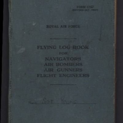
John Youngs’ flying log book for navigators, air bombers, air gunners and flight engineers
Reg Woolgar's observer's and air gunner's flying log book
Tags: 16 OTU; 192 Squadron; 49 Squadron; air gunner; Air Gunnery School; aircrew; Anson; B-17; Battle; bombing; bombing of the Creil/St Leu d’Esserent V-1 storage areas (4/5 July 1944); C-47; Cook’s tour; crash; ditching; Dominie; Halifax; Halifax Mk 3; Hampden; Hudson; Lancaster; Lancaster Mk 1; Lancaster Mk 3; Manchester; Martinet; mine laying; Normandy campaign (6 June – 21 August 1944); Operational Training Unit; Oxford; RAF Barrow in Furness; RAF Foulsham; RAF Fulbeck; RAF Manby; RAF Peterborough; RAF Scampton; RAF Sutton Bridge; RAF Upper Heyford; RAF West Freugh; RAF Wigsley; RAF Yatesbury; Tiger Moth; training; Wellington; Whitley; wireless operator / air gunner; York
Donald Briggs' log book
Tags: 156 Squadron; 8 Group; aircrew; bombing; bombing of Dresden (13 - 15 February 1945); bombing of Luftwaffe night-fighter airfields (15 August 1944); flight engineer; Lancaster; Lancaster Mk 3; Normandy campaign (6 June – 21 August 1944); Pathfinders; RAF Upwood; tactical support for Normandy troops; V-1; V-weapon
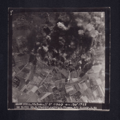
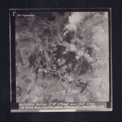
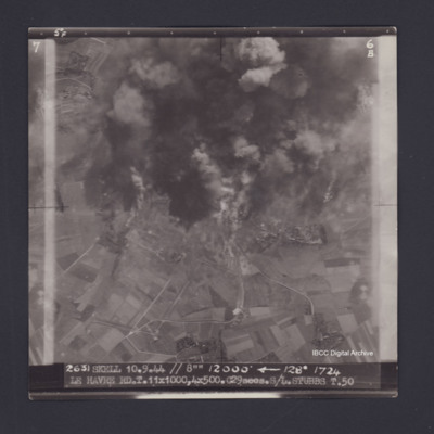
Le Havre
Tom Jones’ navigator’s, air bomber’s and air gunner’s flying log book
Tags: 1657 HCU; 622 Squadron; 7 Squadron; aircrew; anti-aircraft fire; B-24; bombing; bombing of the Normandy coastal batteries (5/6 June 1944); C-47; flight engineer; Heavy Conversion Unit; Lancaster; Lancaster Mk 1; Lancaster Mk 3; mine laying; Normandy campaign (6 June – 21 August 1944); Oxford; Pathfinders; RAF Dishforth; RAF Mildenhall; RAF Nutts Corner; RAF Oakington; RAF Riccall; RAF Stradishall; RAF Warboys; Stirling; tactical support for Normandy troops; target indicator; training; V-1; V-weapon; York
Le Havre
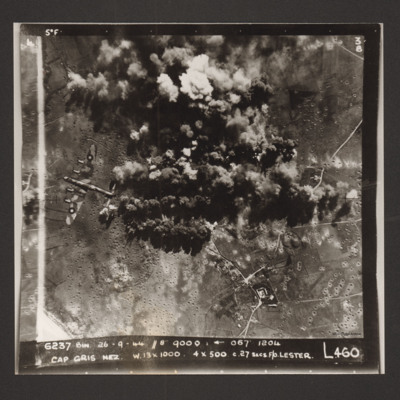
Cap Gris Nez
Harry Thomas Ansell's flying log book for flight engineers
Tags: 1654 HCU; 61 Squadron; 83 Squadron; aircrew; Bennett, Donald Clifford Tyndall (1910-1986); bombing; bombing of Dresden (13 - 15 February 1945); bombing of the Pas de Calais V-1 sites (24/25 June 1944); Distinguished Flying Medal; flight engineer; George VI, King of Great Britain (1895-1952); Heavy Conversion Unit; Initial Training Wing; Lancaster; Lancaster Finishing School; Normandy campaign (6 June – 21 August 1944); Pathfinders; RAF Coningsby; RAF Skellingthorpe; RAF St Athan; RAF Stockport; RAF Syerston; RAF Torquay; RAF Wigsley; Stirling; tactical support for Normandy troops; training
Le Havre
Ernie Twells’ navigator’s, air bomber’s and air gunner’s flying log book
Tags: 1660 HCU; 617 Squadron; 619 Squadron; aircrew; bombing; bombing of Hamburg (24-31 July 1943); bombing of Kassel (22/23 October 1943); bombing of the Boulogne E-boats (15/16 June 1944); bombing of the Juvisy, Noisy-le-Sec and Le Bourget railways (18/19 April 1944); bombing of the Le Havre E-boat pens (14/15 June 1944); Bombing of the Saumur tunnel (8/9 June 1944); bombing of the Siracourt V-weapon site (25 June 1944); bombing of the Watten V-2 site (19 June 1944); bombing of the Wizernes V-2 site (20, 22, 24 June 1944); bombing of Toulouse (5/6 April 1944); C-47; flight engineer; Heavy Conversion Unit; Lancaster; Normandy campaign (6 June – 21 August 1944); Normandy deception operations (5/6 June 1944); Operation Catechism (12 November 1944); Operational Training Unit; RAF Bramcote; RAF Swinderby; RAF Woodhall Spa; Tirpitz; training; Wellington
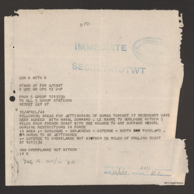
Signal jettison areas 10 April 1944
Tags: 5 Group
Donald Cochrane’s observer's and air gunner's flying log book
Tags: 1657 HCU; 30 OTU; 460 Squadron; aircrew; Anson; bombing; Bombing of Mailly-le-Camp (3/4 May 1944); bombing of Nuremberg (30 / 31 March 1944); bombing of the Boulogne E-boats (15/16 June 1944); bombing of the Le Havre E-boat pens (14/15 June 1944); bombing of the Normandy coastal batteries (5/6 June 1944); Dominie; Heavy Conversion Unit; Lancaster; Lancaster Finishing School; mine laying; Normandy campaign (6 June – 21 August 1944); Operational Training Unit; Proctor; RAF Binbrook; RAF Feltwell; RAF Seighford; RAF Stradishall; Stirling; training; Wellington; wireless operator
Arthur Loudon's flying log book for navigators
Tags: 12 Squadron; 1656 HCU; 1667 HCU; 30 OTU; Advanced Flying Unit; Air Observers School; aircrew; Anson; Battle; bombing; Bombing and Gunnery School; bombing of Dresden (13 - 15 February 1945); Halifax; Heavy Conversion Unit; Lancaster; Lancaster Finishing School; navigator; Operational Training Unit; Oxford; RAF Gamston; RAF Hemswell; RAF Lindholme; RAF Mona; RAF Sandtoft; RAF Seighford; RAF Wickenby; training; Wellington
Calais
James Wrigley's flying log book
Tags: 10 OTU; 1656 HCU; 19 OTU; 199 Squadron; 35 Squadron; 617 Squadron; 635 Squadron; 81 OTU; 83 Squadron; 97 Squadron; Air Gunnery School; aircrew; Anson; B-29; Blenheim; bombing; bombing of Hamburg (24-31 July 1943); bombing of Kassel (22/23 October 1943); bombing of Nuremberg (30 / 31 March 1944); Bombing of Peenemünde (17/18 August 1943); bombing of the Le Havre E-boat pens (14/15 June 1944); Dominie; final resting place; Halifax; Halifax Mk 1; Halifax Mk 2; Heavy Conversion Unit; killed in action; Lancaster; Lancaster Mk 1; Lancaster Mk 3; Lincoln; missing in action; Normandy campaign (6 June – 21 August 1944); Operational Training Unit; Pathfinders; Proctor; RAF Abingdon; RAF Binbrook; RAF Bourn; RAF Downham Market; RAF Hemswell; RAF Kinloss; RAF Lindholme; RAF Marham; RAF Pembrey; RAF Scampton; RAF Shallufa; RAF St Athan; RAF Tilstock; RAF Yatesbury; training; Wellington; Whitley; wireless operator
Jack Hayley’s Royal Canadian Air Force pilots flying log book
Tags: 1667 HCU; 170 Squadron; 625 Squadron; 83 OTU; 83 Squadron; Advanced Flying Unit; aircrew; Anson; bombing; Dominie; Flying Training School; Halifax; Halifax Mk 5; Harvard; Heavy Conversion Unit; Hurricane; Lancaster; Lancaster Finishing School; Lancaster Mk 1; Lancaster Mk 3; Lincoln; Magister; Meteor; Mosquito; Operational Training Unit; Oxford; pilot; RAF Clyffe Pypard; RAF Defford; RAF Dunholme Lodge; RAF Heaton Park; RAF Hemswell; RAF Kelstern; RAF Little Rissington; RAF Madley; RAF Peplow; RAF Peterborough; RAF Sandtoft; RAF Scampton; RAF Windrush; RCAF Estevan; RCAF Moncton; Shackleton; Spitfire; Stearman; Tiger Moth; training; Wellington; York
John Derek Bailey’s Royal Canadian Air Force flying log book for aircrew other than pilot
Tags: 103 Squadron; 1654 HCU; 166 Squadron; 1660 HCU; 1667 HCU; 20 OTU; 83 OTU; Advanced Flying Unit; aircrew; Anson; Bolingbroke; bomb aimer; bombing; Bombing and Gunnery School; Halifax; Halifax Mk 2; Halifax Mk 5; Heavy Conversion Unit; Initial Training Wing; Lancaster; Lancaster Finishing School; Lancaster Mk 3; mine laying; Operational Training Unit; RAF Acaster Malbis; RAF Bicester; RAF Blyton; RAF Catterick; RAF Elsham Wolds; RAF Heaton Park; RAF Hemswell; RAF Kirkham; RAF Kirmington; RAF Lindholme; RAF Llandwrog; RAF Lossiemouth; RAF Moreton in the Marsh; RAF Paignton; RAF Penrhos; RAF Peplow; RAF Sandtoft; RAF Scampton; RAF Swinderby; RAF Wickenby; RAF Wigsley; RAF Worksop; RCAF Moncton; training; Wellington
Arthur Atkins’ flying log book for pilots
Tags: 1662 HCU; 1667 HCU; 27 OTU; 625 Squadron; Advanced Flying Unit; aircrew; Anson; bombing; Flying Training School; Halifax; Halifax Mk 2; Halifax Mk 5; Heavy Conversion Unit; Lancaster; Lancaster Finishing School; Lancaster Mk 1; Lancaster Mk 3; Normandy campaign (6 June – 21 August 1944); Operational Training Unit; Oxford; pilot; RAF Andover; RAF Blyton; RAF Church Broughton; RAF Gamston; RAF Hemswell; RAF Kelstern; RAF Lichfield; RAF Sandtoft; RAF Westcott; tactical support for Normandy troops; Tiger Moth; training; V-1; V-weapon; Wellington
Jack Warner’s navigator's, air bomber's and air gunner's flying log book
Tags: 1659 HCU; 1664 HCU; 408 Squadron; 428 Squadron; aircrew; anti-aircraft fire; bombing; bombing of the Normandy coastal batteries (5/6 June 1944); C-47; flight engineer; Gneisenau; Halifax; Halifax Mk 2; Halifax Mk 5; Heavy Conversion Unit; mine laying; Normandy campaign (6 June – 21 August 1944); RAF Croft; RAF Leeming; RAF Middleton St George; RAF St Athan; RAF Topcliffe; Scharnhorst; training; Window
Andrew Deytrikh’s pilots flying log book. One
Tags: 66 Squadron; aircrew; B-17; B-25; B-26; bombing; Boston; Flying Training School; Fw 190; Hurricane; Magister; Me 109; Me 110; Operational Training Unit; pilot; RAF Brough; RAF Hornchurch; RAF Kenley; Spitfire; Tiger Moth; training; Typhoon; V-1; V-weapon
Angas M Hughes’ Royal Australian Air Force observer’s air gunner’s and wireless operator’s flying log book
Tags: 1660 HCU; 27 OTU; 467 Squadron; Advanced Flying Unit; Air Observers School; aircrew; Anson; Battle; bomb aimer; bombing; bombing of Luftwaffe night-fighter airfields (15 August 1944); bombing of the Creil/St Leu d’Esserent V-1 storage areas (4/5 July 1944); bombing of the Pas de Calais V-1 sites (24/25 June 1944); Bombing of Trossy St Maximin (3 August 1944); Heavy Conversion Unit; Lancaster; Lancaster Finishing School; Lancaster Mk 1; Lancaster Mk 3; missing in action; Normandy campaign (6 June – 21 August 1944); Operational Training Unit; RAF Lichfield; RAF Swinderby; RAF Syerston; RAF Waddington; RAF West Freugh; Stirling; tactical support for Normandy troops; training; V-1; V-weapon; Wellington
L Kirrage's flying log book for navigators, air bombers. air gunners and flight engineers
Robert McClement's Flying Log Book for Navigators, Air Bombers, Air Gunners, Flight Engineers
Tags: 10 Squadron; 1658 HCU; 20 OTU; air gunner; Air Gunnery School; aircrew; Anson; bombing; bombing of Luftwaffe night-fighter airfields (15 August 1944); FIDO; Halifax; Halifax Mk 2; Halifax Mk 3; Heavy Conversion Unit; Normandy campaign (6 June – 21 August 1944); Operation Manna (29 Apr – 8 May 1945); Operational Training Unit; RAF Lossiemouth; RAF Melbourne; RAF Pembrey; RAF Riccall; tactical support for Normandy troops; training; V-1; V-weapon; Wellington
Le Havre
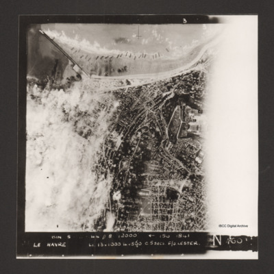
Le Havre
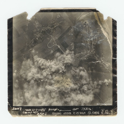
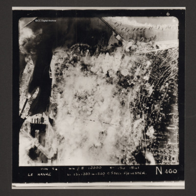
Captioned 'Captioned 'BIN 5-8-44 //8 12000' [arrow] 150 1841 Le Havre Li 13x1000 4x500 c5secs F/O Lester N 460'.

