Browse Items (270 total)

  • Tags: reconnaissance photograph

PWillettS1935.jpg
Vertical aerial photograph showing floodwater from the breeched Eder Dam surrounding buildings and covering roads. Reverse of image annotated '17-5-43 Affoldern (Eder) Eder Dam flooding'.

PWillettS1933.jpg
Vertical aerial photograph showing fields, forest, roads, two areas of buildings and floodwater. Remains of bridges visible in the floodwater. Reverse of the image annotated 'Affoldern (Eder Dam) 19-5-43'.

PWillettS1930.jpg
A vertical aerial photograph showing nineteen ships. Smoke trails are visible coming from 2 ships. Negative number 4068. Caption '155B/60L/3PG/20. Oct. 43/1330/F24/29,550'.'

PWillettS1928.jpg
Vertical aerial photograph of Staryi Saltiv with caption in German. Several features along the Donets River are numbered and circled. Handwritten annotation 'Starys - Ssaltoff' on lower right side of image. Handwritten annotation on reverse "etwa…

PWillettS1926.jpg
Oblique aerial photograph of Anthéor viaduct.

PWillettS1922.jpg
Oblique aerial photograph of the base of the Anthéor railway viaduct. Bomb damaged buildings visible. Annotated on the reverse 'Anthéor viaduct (S. France) E229 0043'.

PWillettS1921.jpg
Two vertical aerial photographs showing before and after images of Krefeld with caption 'Krefeld Photographs "before" and "after" the attack in June 1943 in which over 40% of the town was devastated in a single night. This town is important at the…

PWillettS1920.jpg
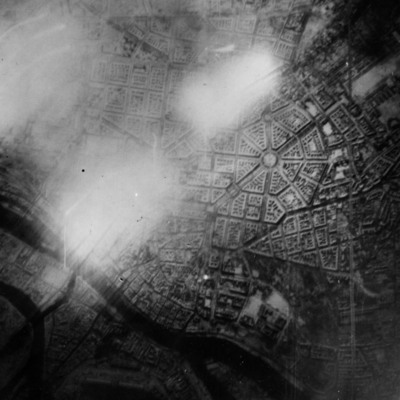
Vertical aerial photograph with caption '3056 12 PRB207. 3PG. 20 Aug 1944.,09.10. F/24. 20,000'.'.
The river Arno and railway run parallel from the top to the bottom of the image. The village on the left is Lastra a Signa, the part village top…

PWillettS1918.jpg
Vertical aerial photograph of Calenzano Alto with the Torrente Marina. Captioned '4132 12PR/B-207 3PG 20th August 1944/0910/F24"/20,000'.'.

Identification kindly provided by Dave Lamport of the Finding the location WW1 & WW2 Facebook group.

PWillettS1917.jpg
Vertical aerial photograph with caption '4074 12PRB207.3PG. 20 Aug 1944. 09.10. F/24. 20.000'.'. A runway is visible on the right side of the image. There are three rows of bomb craters across the runway and several craters in the fields adjacent…

PWillettS1916.jpg
Vertical aerial photograph of Fiesole with caption '4038 12 PRB207. 3PG. 20 Aug 1944. 09.10. F/24.20.000'.'.

Identification kindly provided by Dave Lamport of the Finding the location WW1 & WW2 Facebook group.

PWillettS1915.jpg
Vertical aerial photograph of a hilly terrain east of Pian di Mugnone and Fiesole, centered around the intersection of Strada Provinciale 54 with Strada Provinciale 55. Captioned: '4036 12 PRB 207. 3PG. 20 Aug 1944. 09.10. F/24.…

PWillettS1914.jpg
A vertical aerial photograph of hilly terrain north of Serpiolle. The Florence-Faenza railway is partly visible in the lower-right corner. Captioned '3108 12PR/B-207 3PC 20th August 1944/0910/F24"/20,000'.'. Identification kindly provided by Dave…

PWillettS1913.jpg
Vertical aerial photograph captioned '672Z45 v.31.8.40 Manchester Engl. B1. 12 GB45101 45102'. The top left and right corners of the print have images of instruments and the bottom right corner has the caption 'Nr 899 033 f = 200.92'. The centre…

Reconnaissance photograph
A vertical reconnaissance photograph in a plastic bag labelled by the collection owner '15th July 1943 Good possibility between Düsseldorf and Duisburg (River Rhur) The photograph is captioned 'RA596 140 15 Jul 43// FIOA 12' TB'. One of a series of…

PWillettS19030035.jpg
Vertical reconnaissance photograph captioned '5005 RA362 140 18 May 43// F34 12" (TB)', showing fields and roads leading to a large town in the top right of the image.

PWillettS19030034.jpg
Vertical reconnaissance photograph captioned '5082 RA596 140 15 Jul 43// FIOA 12' TB', showing fields, roads and tracks and fire breaks in an area of forest plantation. One of a series of reconnaissance photographs printed on thin bright alloy.

PWillettS19030033.jpg
Vertical reconnaissance photograph captioned 'RA596 140 15 Jul 43// FIOA 12' TB', showing fields, roads and tracks and fire breaks in an area of forest plantation. One of a series of reconnaissance photographs printed on thin bright alloy.

PWillettS19030032.jpg
Vertical reconnaissance photograph captioned 'RA596 140 15 Jul 43// FIOA 12' TB', showing fields and roads. Buildings in small towns or villages are also visible. One of a series of reconnaissance photographs printed on thin bright alloy.

PWillettS19030031.jpg
Vertical reconnaissance photograph captioned '5111 RA596 140 15 Jul 43// FIOA 12' TB', showing fields and roads to the left and right of the image. A river runs across the bottom of the image. A second river runs from top left to the right side of…

PWillettS19030030.jpg
Vertical reconnaissance photograph captioned '5110 RA596 140 15 Jul 43// FIOA 12' TB', showing fields and roads to the left of the image. The Loire river runs across the bottom of the image. Orleans is visible at he bottom of the photograph. A second…

PWillettS19030029.jpg
Vertical reconnaissance photograph captioned '5109 RA596 140 15 Jul 43// FIOA 12' TB', showing fields and roads to the left of the image. The Loire river runs across the bottom of the image. Orleans is visible below the river. A second river runs…

PWillettS19030028.jpg
Vertical reconnaissance photograph captioned '5108 RA596 140 15 Jul 43// FIOA 12' TB', showing fields and roads to the left of the image. The Loire river runs across the bottom of the image. Orleans is visible below the river. A second river runs…

PWillettS19030027.jpg
Vertical reconnaissance photograph captioned '5107 RA596 140 15 Jul 43// FIOA 12' TB', showing fields, roads and areas of forest. The Loire river runs across the bottom of the image. A second river runs across the top right corner of the image. One…

PWillettS19030026.jpg
Vertical reconnaissance photograph captioned '5106 RA596 140 15 Jul 43// FIOA 12' TB', showing fields, roads and areas of forest. A river runs across the bottom of the image. One of a series of reconnaissance photographs printed on thin bright…
Output Formats

atom, dc-rdf, dcmes-xml, json, omeka-xml, rss2