Vlissingen
Title
Vlissingen
Description
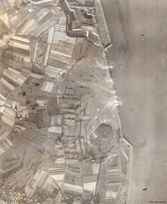
A vertical aerial photograph showing several new breaches in the sea defences with areas of land in process of being flooded. Submitted with caption; “Sea wall broken at Flushing.” Fort Rammekens is at the top of the photograph, with village of Ritthem to the bottom. A large six sided grass covered structure, possibly a fortification, can be seen towards the bottom of the photograph, surrounded by floodwater. A bomb crater can be seen in the middle of this structure together with many other bomb craters scattered over the adjacent farmland
Date
1943-05-15
Temporal Coverage
Type
Format
One b/w photograph
Conforms To
Publisher
Rights
This content is available under a CC BY-NC 4.0 International license (Creative Commons Attribution-NonCommercial 4.0). It has been published ‘as is’ and may contain inaccuracies or culturally inappropriate references that do not necessarily reflect the official policy or position of the University of Lincoln or the International Bomber Command Centre. For more information, visit https://creativecommons.org/licenses/by-nc/4.0/ and https://ibccdigitalarchive.lincoln.ac.uk/omeka/legal.
Contributor
Identifier
PEleyNJ1621
Collection
Citation
“Vlissingen,” IBCC Digital Archive, accessed July 26, 2024, https://ibccdigitalarchive.lincoln.ac.uk/omeka/collections/document/28575.
Item Relations
This item has no relations.

