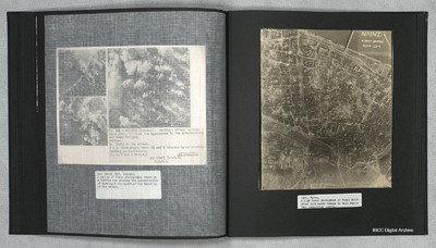
Mainz
Title
Mainz
Description
A vertical aerial photograph of Mainz. The
top right of the image shows the Rhine. The
bridge is Theodor-Heuss Brucke. The large
L shaped building to its left is Kurfurstliches
Schloss with various large government
buildings below it. The wide street to the left
running from top to the railway station is
KaiserStrasse with the destroyed
Christuskirche at its widest point near the
top. Mainz Hauptbahnhof is located in the
lower left. Destroyed buildings and bomb
craters are visible throughout the largely
residential area of the city.
Date
1945
Temporal Coverage
Language
Type
Format
One b/w photograph on an album page
Conforms To
Publisher
Rights
This content is available under a CC BY-NC 4.0 International license (Creative Commons Attribution-NonCommercial 4.0). It has been published ‘as is’ and may contain inaccuracies or culturally inappropriate references that do not necessarily reflect the official policy or position of the University of Lincoln or the International Bomber Command Centre. For more information, visit https://creativecommons.org/licenses/by-nc/4.0/ and https://ibccdigitalarchive.lincoln.ac.uk/omeka/legal.
Contributor
Identifier
PThomasAF20040038
Collection
Citation
“Mainz,” IBCC Digital Archive, accessed July 27, 2024, https://ibccdigitalarchive.lincoln.ac.uk/omeka/collections/document/23036.
Item Relations
This item has no relations.

