Ouistreham and Port de L'Orne
Title
Ouistreham and Port de L'Orne
Description
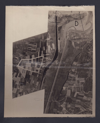
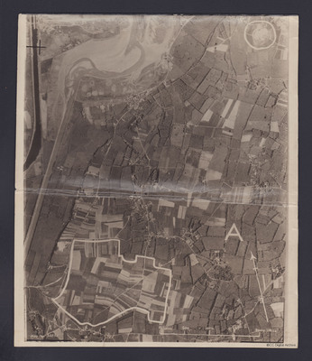
Two reconnaissance photographs of the area to the south and east of Ouistreham and Port de L'Orne. The two photographs overlap.
#1 which is marked "Neg No 38858" shows the Ouistreham Estuary at the top with the Canal de Caen a la Mer running top to bottom with the river Orne running parallel to its right. The River Orne bridge is towards the bottom right. The adjacent Pegasus Bridge section is just off the edge of this photograph but the Village of Benouville is visible on the bottom left. Two areas of interest have been marked in white and a capital "D" is printed over the estuary.
#2 is marked "Neg No 38855" and is slightly east of #1. It also has areas marked with a white border. One is a area of fields to the bottom marked "A" and a circle in the top right which is Merville Battery.
Date
1944
Temporal Coverage
Spatial Coverage
Coverage
Language
Type
Format
Two b/w photographs
Conforms To
Publisher
Rights
This content is available under a CC BY-NC 4.0 International license (Creative Commons Attribution-NonCommercial 4.0). It has been published ‘as is’ and may contain inaccuracies or culturally inappropriate references that do not necessarily reflect the official policy or position of the University of Lincoln or the International Bomber Command Centre. For more information, visit https://creativecommons.org/licenses/by-nc/4.0/ and https://ibccdigitalarchive.lincoln.ac.uk/omeka/legal.
Contributor
Identifier
POatesJ1744, POatesJ1745
Collection
Citation
“Ouistreham and Port de L'Orne,” IBCC Digital Archive, accessed July 7, 2024, https://ibccdigitalarchive.lincoln.ac.uk/omeka/collections/document/38100.
Item Relations
This item has no relations.


