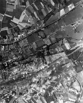
Dreux Rail Facilities
Title
Dreux Rail Facilities
Description
A vertical aerial photograph of Dreux, with rail facility in lower left quarter. Main line runs from rail facilities to top right, with secondary line veering off to the right and curving down to bottom right hand corner. Town is above the railway, with predominately farmland below it. Many bomb craters throughout, above and below rail facilities. Several strings of railway wagons and probably coaches are visible in the sidings and on the secondary line. A number have been damaged by bomb blast and thrown off the tracks. Further bomb craters extend to industrial buildings near the railway with some notably damaged. Distinctive wooded square to the middle right of photograph is the Domaine de Comteville. Photograph labelled; “Dreux Rail Facilities Immediate Report K2423[?], shows bomb damage to region around rail facilities, submitted with caption; “Dreux, N. France”)
Type
Format
One b/w photograph
Conforms To
Publisher
Rights
This content is available under a CC BY-NC 4.0 International license (Creative Commons Attribution-NonCommercial 4.0). It has been published ‘as is’ and may contain inaccuracies or culturally inappropriate references that do not necessarily reflect the official policy or position of the University of Lincoln or the International Bomber Command Centre. For more information, visit https://creativecommons.org/licenses/by-nc/4.0/ and https://ibccdigitalarchive.lincoln.ac.uk/omeka/legal.
Contributor
Identifier
PEleyNJ1623
Collection
Citation
“Dreux Rail Facilities,” IBCC Digital Archive, accessed July 27, 2024, https://ibccdigitalarchive.lincoln.ac.uk/omeka/collections/document/28577.
Item Relations
This item has no relations.

