Map and photographs of targets
Title
Map and photographs of targets
Description
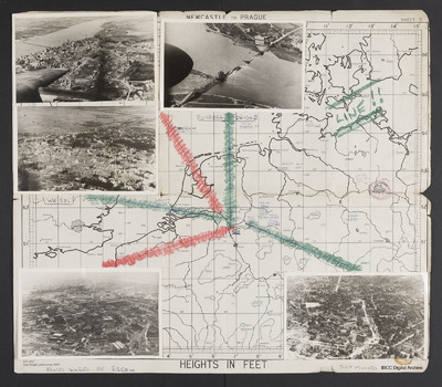
Map (Newcastle to Prague) with five photographs overlaid with lines leading to their locations on map. Top left - a town with destroyed buildings below a wide river with a bridge. Aircraft port outer engine and wingtip visible. Captioned 'Emmerich'. Top centre a destroyed bridge across a wide river. Captioned 'Duisberg [sic] Bridge' Middle left - a town with many destroyed buildings occupying the lower part of image with open fields beyond. Captioned 'Wesel'. Bottom left - Large industrial works with destroyed buildings. Captioned Krupps works at Essen. Bottom right - town with church centre right and many destroyed buildings. Captioned 'Dortmund'. Other targets are underlined and appended with dates.
Creator
Temporal Coverage
Spatial Coverage
Format
Map with five b/w photographs
Publisher
Rights
This content is available under a CC BY-NC 4.0 International license (Creative Commons Attribution-NonCommercial 4.0). It has been published ‘as is’ and may contain inaccuracies or culturally inappropriate references that do not necessarily reflect the official policy or position of the University of Lincoln or the International Bomber Command Centre. For more information, visit https://creativecommons.org/licenses/by-nc/4.0/ and https://ibccdigitalarchive.lincoln.ac.uk/omeka/legal.
Identifier
CBrittainJT-170725-010002, CBrittainJT-170725-010003
Collection
Citation
John Taylor Brittain, “Map and photographs of targets,” IBCC Digital Archive, accessed July 22, 2024, https://ibccdigitalarchive.lincoln.ac.uk/omeka/collections/document/9924.
Item Relations
| This Item | dcterms:relation | Item: Map of Cooks Tour June 1945 |


