Route National 158
Title
Route National 158
Description
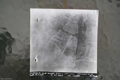
Image shows open countryside with Route National 158 between Caen and Falaise. Captioned '4425HLM.14-8-44//8" 6000 >140 degrees 1444 Tractable 22 RD, B16x500 c 23 secs F/S Jubb M76'.
Identification kindly provided by Ray Moroney of the Finding the location WW1 & WW2 Facebook group.
This item was sent to the IBCC Digital Archive already in digital form. No better quality copies are available.
Identification kindly provided by Ray Moroney of the Finding the location WW1 & WW2 Facebook group.
This item was sent to the IBCC Digital Archive already in digital form. No better quality copies are available.
Date
1944-08-14
Temporal Coverage
Type
Format
One b/w photograph
Conforms To
Publisher
Rights
This content is available under a CC BY-NC 4.0 International license (Creative Commons Attribution-NonCommercial 4.0). It has been published ‘as is’ and may contain inaccuracies or culturally inappropriate references that do not necessarily reflect the official policy or position of the University of Lincoln or the International Bomber Command Centre. For more information, visit https://creativecommons.org/licenses/by-nc/4.0/ and https://ibccdigitalarchive.lincoln.ac.uk/omeka/legal.
Identifier
SWeirG19660703v110004-0011
Collection
Citation
“Route National 158,” IBCC Digital Archive, accessed July 3, 2024, https://ibccdigitalarchive.lincoln.ac.uk/omeka/collections/document/34725.
Item Relations
This item has no relations.

