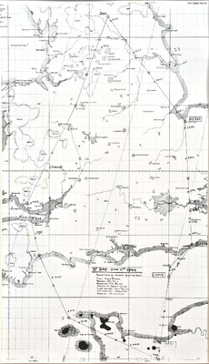
'D' Day Route of Steve Puskas
Title
'D' Day Route of Steve Puskas
Description
A route, with times, flown by Steve Puskas in 'Sweet Adeline' on D Day. The route starts in Yorkshire then Kings Lynn, East of Eastbourne, SSE of Caen, N of Gurnsey, SE of Exeter, E of Porthcawl, W of Stoke-on-Trent then back to base. The aircraft and crew are named on the map.
Date
1944-06-05
1944-06-06
Spatial Coverage
Language
Type
Format
One printed map with annotations
Publisher
Rights
This content is available under a CC BY-NC 4.0 International license (Creative Commons Attribution-NonCommercial 4.0). It has been published ‘as is’ and may contain inaccuracies or culturally inappropriate references that do not necessarily reflect the official policy or position of the University of Lincoln or the International Bomber Command Centre. For more information, visit https://creativecommons.org/licenses/by-nc/4.0/ and https://ibccdigitalarchive.lincoln.ac.uk/omeka/legal.
Identifier
PCothliffKB15110021
Transcription
D Day – June 6th 1944
Route taken by aircraft A of 429 Sqdn
Pilot -Steve Dukas
Navigator, Jas Still
Bomb aimer ‘Turk’ Bowles
Wireless op. ‘Gopher’ Wilson’
Flight Engineer. Jack Phillips
Mid Upper AG. Harry Venn
Rear AG. Al Williams
Route taken by aircraft A of 429 Sqdn
Pilot -Steve Dukas
Navigator, Jas Still
Bomb aimer ‘Turk’ Bowles
Wireless op. ‘Gopher’ Wilson’
Flight Engineer. Jack Phillips
Mid Upper AG. Harry Venn
Rear AG. Al Williams
Collection
Citation
“'D' Day Route of Steve Puskas,” IBCC Digital Archive, accessed November 15, 2024, https://ibccdigitalarchive.lincoln.ac.uk/omeka/collections/document/24997.
Item Relations
This item has no relations.

