Industrial complex to the south of Lincoln
Title
Industrial complex to the south of Lincoln
Description
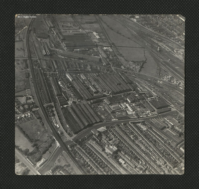
An oblique aerial photograph of a large industrial complex to the south of the city of Lincoln. The industrial area to the top of the photograph became known as New Boultham, whereas the buildings in the centre, a mix of industrial and residential, were known as Boiler Works. The River Witham can be seen flowing through the centre of this photograph. A number of bridges appear, including Firth Road and Rope Walk, crossing over the River Witham, allowing access to the industrial area and the train lines to the top. To the bottom of the photograph, residential areas can be seen. To the far-right side of the photograph, the Foss Dyke flows to the Brayford Pool. Train lines stretch across the centre-right leading to Lincoln Central Station or Midland Station fit with a coal loading station with a turntable. Boultham Avenue can be seen to the bottom left of the photograph, turning under the trainline at the centre-left. The Crown Mill building can be seen at the bottom of the photograph.
Coverage
Type
Format
One b/w photograph
Conforms To
Publisher
Rights
This content is available under a CC BY-NC 4.0 International license (Creative Commons Attribution-NonCommercial 4.0). It has been published ‘as is’ and may contain inaccuracies or culturally inappropriate references that do not necessarily reflect the official policy or position of the University of Lincoln or the International Bomber Command Centre. For more information, visit https://creativecommons.org/licenses/by-nc/4.0/ and https://ibccdigitalarchive.lincoln.ac.uk/omeka/legal.
Contributor
Identifier
PEdgarAG19010036
Collection
Citation
“Industrial complex to the south of Lincoln,” IBCC Digital Archive, accessed July 22, 2024, https://ibccdigitalarchive.lincoln.ac.uk/omeka/collections/document/23705.
Item Relations
This item has no relations.

