Le Havre
Title
Le Havre
Description
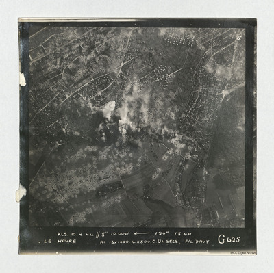
A vertical aerial photograph taken during an operation at Le Havre, centered on the Aplemont district, near the Forêt de Montgeon. The central area has explosions and smoke and many bomb craters are visible.
It is captioned 'KLS 10.0.44//8" 10,000' ,--120° 18.40 Le Havre A1 13x1000 4x500 c24 secs F/L Davy G625'.
Identification kindly provided by David Byrden of the Finding the location WW1 & WW2 Facebook group.
It is captioned 'KLS 10.0.44//8" 10,000' ,--120° 18.40 Le Havre A1 13x1000 4x500 c24 secs F/L Davy G625'.
Identification kindly provided by David Byrden of the Finding the location WW1 & WW2 Facebook group.
Date
1944-09-10
Temporal Coverage
Language
Type
Format
One b/w photograph
Conforms To
Publisher
Rights
This content is available under a CC BY-NC 4.0 International license (Creative Commons Attribution-NonCommercial 4.0). It has been published ‘as is’ and may contain inaccuracies or culturally inappropriate references that do not necessarily reflect the official policy or position of the University of Lincoln or the International Bomber Command Centre. For more information, visit https://creativecommons.org/licenses/by-nc/4.0/ and https://ibccdigitalarchive.lincoln.ac.uk/omeka/legal.
Identifier
PDavyFR1909
Collection
Citation
“Le Havre,” IBCC Digital Archive, accessed July 27, 2024, https://ibccdigitalarchive.lincoln.ac.uk/omeka/collections/document/43523.
Item Relations
This item has no relations.

