Calais
Title
Calais
Description
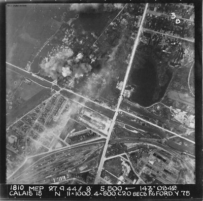
A vertical aerial photograph of Calais. The canal, Canal des Pierrettes, is visible and runs left to right, parallel to Rue Hoche and a marshalling yard. The yard services Les Fontinettes train station. Annotated '1810 MEP 27.9.44// 8” 5,500 [arrow] 143[degrees] 0842. CALAIS. N. 11 x 1000. 4x500. C 20 SECS. F/O FORD. Y.75'.
A body of water, Flaque Carpentier, is positioned at the top middle of the image above explosion sites, affecting the area between Rue de Tunis and Chemin Vert. The majority is clear with much urban detail.
A body of water, Flaque Carpentier, is positioned at the top middle of the image above explosion sites, affecting the area between Rue de Tunis and Chemin Vert. The majority is clear with much urban detail.
Date
1944-09-27
Temporal Coverage
Language
Type
Format
One b/w photograph
Conforms To
Publisher
Rights
This content is available under a CC BY-NC 4.0 International license (Creative Commons Attribution-NonCommercial 4.0). It has been published ‘as is’ and may contain inaccuracies or culturally inappropriate references that do not necessarily reflect the official policy or position of the University of Lincoln or the International Bomber Command Centre. For more information, visit https://creativecommons.org/licenses/by-nc/4.0/ and https://ibccdigitalarchive.lincoln.ac.uk/omeka/legal.
Identifier
PFordTA17030005
Collection
Citation
“Calais,” IBCC Digital Archive, accessed November 14, 2024, https://ibccdigitalarchive.lincoln.ac.uk/omeka/collections/document/23957.
Item Relations
This item has no relations.

