Calais
Title
Calais
Description
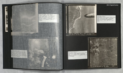
Photo 1 is a vertical aerial photograph of the coast with bomb craters. A 1000lb bomb cab be seen falling in the right of the image.
Photo 2 is a vertical aerial photograph of the Calais area. The operation is to destroy a rocket launch site. Many bomb craters can be seen.
Photo 2 is a vertical aerial photograph of the Calais area. The operation is to destroy a rocket launch site. Many bomb craters can be seen.
Date
1944-09-26
Temporal Coverage
Language
Type
Format
Two b/w photographs on an album page
Conforms To
Publisher
Rights
This content is available under a CC BY-NC 4.0 International license (Creative Commons Attribution-NonCommercial 4.0). It has been published ‘as is’ and may contain inaccuracies or culturally inappropriate references that do not necessarily reflect the official policy or position of the University of Lincoln or the International Bomber Command Centre. For more information, visit https://creativecommons.org/licenses/by-nc/4.0/ and https://ibccdigitalarchive.lincoln.ac.uk/omeka/legal.
Identifier
PThomasAF20040014
Transcription
[Photograph]
2984 GLY. 26/9/44//8” 5800’ [symbol] 062° 1207.24sec
CALAIS A/P 7c. D. 6R. 4RCV. 4x1000. C21 F/O OSMOND. T35
26/9/1944. Calais.
A daylight attack on rocket launch sites. Time 12-07. Height 5800’. Photograph taken by T-Tommy of 35 Squadron. Photo shows a 1000lb bomb on its way down.
26/9/1944. Calais.
A daylight attack on rocket launch sites. Time 12-04. Height 8000’. Photograph taken by S-Sugar of 35 Squadron flown by F/O Marsden.
[photograph]
2989. GLY. 26/9/44//8” 8000’ [symbol] 072° 1204
CALAIS A/P 7C. S. 6R.4RCV C21 F/O MARSDEN S35
Collection
Citation
“Calais,” IBCC Digital Archive, accessed July 26, 2024, https://ibccdigitalarchive.lincoln.ac.uk/omeka/collections/document/23004.
Item Relations
This item has no relations.

