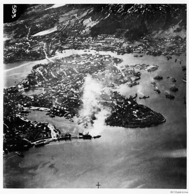
Bergen harbour
Title
Bergen harbour
Description
An oblique aerial photograph of Bergen Harbour showing a number of vessels operating in the waters surrounding the town. Bergen occupies the central part of the image and in the centre left of the image can be seen the water of Lille Lungegardsvannet, next to the Festplassen. Above this is the road bridge to Kronstad. To the right of the bridge are several moored vessels and in the wider part of the harbour there appear to be barges loading or unloading moored ships. A steamer can be seen approaching or leaving a pier. There is some cloud or smoke obscuring part of Bergen but the smaller harbour, which lies to the north of the town, is clearly visible and some more shipping can be seen alongside the wharf. The breakwater protecting this harbour is clearly visible at the bottom of the image. The image is annotated with the numbers "583" in the top left corner.
Type
Format
One b/w photograph
Conforms To
Publisher
Rights
This content is available under a CC BY-NC 4.0 International license (Creative Commons Attribution-NonCommercial 4.0). It has been published ‘as is’ and may contain inaccuracies or culturally inappropriate references that do not necessarily reflect the official policy or position of the University of Lincoln or the International Bomber Command Centre. For more information, visit https://creativecommons.org/licenses/by-nc/4.0/ and https://ibccdigitalarchive.lincoln.ac.uk/omeka/legal.
Contributor
Identifier
PWhittakerH17020003
Collection
Citation
“Bergen harbour,” IBCC Digital Archive, accessed July 22, 2024, https://ibccdigitalarchive.lincoln.ac.uk/omeka/collections/document/39388.
Item Relations
This item has no relations.

