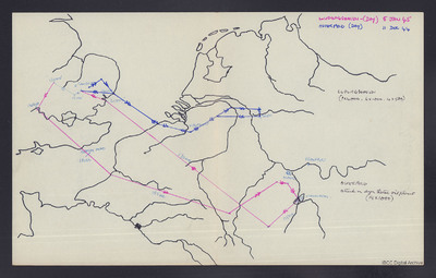
Route map - Ludwigshafen and Osterfeld
Title
Route map - Ludwigshafen and Osterfeld
Description
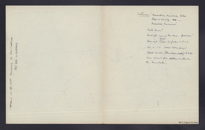
Outline map of England and north west Europe. Shows separate routes to Ludwigshafen on 5 January 1945 and Osterfeld on 11 December 1944. Both operations by day. Includes bomb load for both. On the reverse note 'Captain's of a/c map belonging to Ron Chapman 195 Sqn, Witchford'. Includes comment 'Marmalade, marmalade, British troops in vicinity .... marmalade, marmalade, Master Bomber?, searchlights against the clouds, firts wave [.......] No marker ot T.I's, 109 and 110 passed below going opposite direction, orbited once, [..] much flak [...] another turn then marmalade'.
Spatial Coverage
Format
One map with handwritten notes on reverse
Publisher
Rights
This content is available under a CC BY-NC 4.0 International license (Creative Commons Attribution-NonCommercial 4.0). It has been published ‘as is’ and may contain inaccuracies or culturally inappropriate references that do not necessarily reflect the official policy or position of the University of Lincoln or the International Bomber Command Centre. For more information, visit https://creativecommons.org/licenses/by-nc/4.0/ and https://ibccdigitalarchive.lincoln.ac.uk/omeka/legal.
Contributor
Identifier
CCuthillCR-180818-010007, CCuthillCR-180818-010008
Transcription
[map]
LUDWIGSHAVEN – (DAY) 5 JAN 45
OSTERFELD (DAY) 11 DEC 44
[page break]
CAPTAIN’S OF A/C MAP BELONGING TO RON CHAPMAN.
195 SQN WITCHFORD
[underlined] Dortmund [/underlined] – “Marmalade, Marmalade, British troops in vicinity. [deleted] Mar [/deleted] Marmalade, Marmalade”.
Master Bomber?
Searchlights [underlined] against [/underlined] the cloud first wave?
Gone up to target. No marker or T.I.’s.
109 & 110 passed below going in opposite direction (deleted] then marmalade [/deleted] Orbited Once not much flak, [deleted] [indecipherable word] [/deleted] another turn then “Marmalade”.
Collection
Citation
“Route map - Ludwigshafen and Osterfeld,” IBCC Digital Archive, accessed July 26, 2024, https://ibccdigitalarchive.lincoln.ac.uk/omeka/collections/document/38407.
Item Relations
This item has no relations.


