Bodenorganisation Großraum-Nachtjagd Luftflotte Reich
Title
Bodenorganisation Großraum-Nachtjagd Luftflotte Reich
Reich Ground Organisation for Long-Range Air Fleet Night Fighter Defence
Description
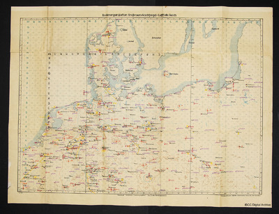
Map showing north Germany, Denmark, Netherlands, part of Belgium and France. Goes east to include Poland and parts of Lithuania. Symbols on map with legend on reverse. Symbols are of German air force aviation objects and defensive systems.
Language
Type
Format
One map
Publisher
Rights
This content is available under a CC BY-NC 4.0 International license (Creative Commons Attribution-NonCommercial 4.0). It has been published ‘as is’ and may contain inaccuracies or culturally inappropriate references that do not necessarily reflect the official policy or position of the University of Lincoln or the International Bomber Command Centre. For more information, visit https://creativecommons.org/licenses/by-nc/4.0/ and https://ibccdigitalarchive.lincoln.ac.uk/omeka/legal.
Identifier
CRennisonJ-160224-010001, CRennisonJ-160224-010002, CRennisonJ-160224-010003
Transcription
FRONT SIDE:
Top: Ground personnel greater night-fighting area – Air Fleet Reich
Bottom: Northern Sheet 1:2,000,000 (Mercator Projection) – For service use only!
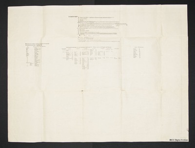
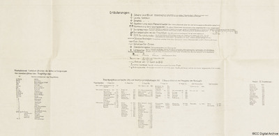
BACK SIDE:
Upper central section:
Explanation:
- Heavy beacon light: a revolving searchlight, and in 400m distance away, pointing towards an airfield for night landing, a Morse-identification beacon, which has the first letter of the beacon light’s name as marker beacon signal.
- Light radio beacon
- Heavy radio beacon
- VI “Object identifier” using anti-aircraft artillery searchlight: the identification marks given on the map are irradiated using 150cm-searchlights.
- “Object identifier” using flare shells: flare shells with the depicted signs are shot at bigger objects.
- Breakthrough shooting: for all the identification marks classified for the shooting of object identifiers, in case of bad weather conditions, alternating with the identification mark, five flare shells are shot vertically one above the other with 500m altitude gradation above the cloud cover.
Minimum weather conditions for shooting:
With 10/10 cloud cover: cloud base 1000m
With 9/10 cloud cover: cloud base 900m
With 8/10 cloud cover: cloud base 800m
Feuersicht (fire vision ?) 5km.
- Breakthrough shooting near the airfields: every two minutes a flare shell is shot above the clouds.
- SSR (Schein Signal Raketen) decoy skymarking rockets – breakthrough shooting: At the existing SSR facilities red parachute flares are shot every 3 min. above the cloud cover; prerequisite: over 5/10 cloud cover and a cloud top, that makes the detection of signal rockets more likely. Minimum weather conditions as forementioned!
- Searchlight paths: searchlights are standing at distances of about 10km from each other with an inclination angle of 45° towards the road.
- Anti-aircraft artillery areas
- Searchlight areas
- Data for the flare shells and searchlight positions
- „Light Spitter“, [the „Flaming Onion“ revolving cannon]. Using light anti-aircraft artillery, five rounds of semi automatic fire with maximum gun elevation are fired every 20 seconds, ([in conditions]) when a cloud cover over 5/10 and a cloud top and cloud base are existing, that make the detection of the tracer ammunition above the clouds from the aircraft more likely, and also in case of visibility below 3 km, regardless of the cloud cover.
- Radar (Fu.M.G.=Funkmessgerät) positioning:
First order; second order; third order; positioning not ready for use
31= height of the point above sea level [über N. n. = above standard zero]
(214)= camouflage number
- Border between Air Fleet Reich and Air Fleet 3
- Light beacon light, which has the letter „T“ as standardized identification code.
- “Richtungsleuchten” (directional lamps ?)= directional searchlight, which shine towards the side facing away from the border as protection against border overflight.
Lower central section:
Night-fighting home airdrome (H) and night fighting “Einfall” (Hub ?) airdrome (E) (Status:21.6.44) with camouflage number data
Airport size: 1st Fighter Division 2nd Fighter Div. 3rd Fighter Div. 7th Fighter Div. 8th Fighter Div. Fighter Commander East Prussia Fighter Commander Slesia
1000-1200m
1200-1400m
1400 and above
Left section:
The following radio beacons irradiate the cloud base of the airfields nearby:
FF (Funk Feuer=radio beacon) cloud base above the airfield
Ludwig Vechta
Marie Lüneburg
Berta Brandenburg-Briest
Otto Rhein-Main
Kuli St. Dizier
Janatz Memmingen
Ida
Ponto
Phillipp
Dagmar
Markgraf
Christa
Herzog
Nr. 1
Nr. 2
….
Radio Beacon Position Puma
Radio Beacon Position Squirrel
Radio Beacon Position Zebra
Radio beacon position
Radio beacon position Seal
Right section:
Airdrome II Fighter Corps
Chieves 404
Florennes 401
Juvincourt 403
Laon-Athies 402
Vendeville 405
Avorol 509
Bretigny 505
Chartres 506
Chateaudun 507
Coulommiers 504
Dijon 501
St. Dizier 502
Lyon-Bron 510
Taveaux 503
Tours 508
Collection
Citation
“Bodenorganisation Großraum-Nachtjagd Luftflotte Reich,” IBCC Digital Archive, accessed July 25, 2024, https://ibccdigitalarchive.lincoln.ac.uk/omeka/collections/document/30252.
Item Relations
This item has no relations.


