Medicine Hat
Title
Medicine Hat
Description
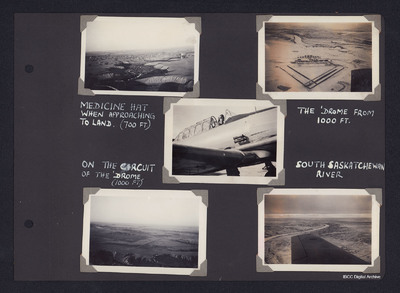
Top left - air to ground view of river valley winding up from bottom with terraces either side and a town in middle distance. Captioned 'Medicine Hat when approaching to land (700 Ft)'. Top right - air to ground view of an airfield with triangular runway layout and buildings at top. In the distance open countryside and a river. Captioned 'The drome from 1000 Ft'. Centre middle - View of front starboard side of Harvard with pilot in cockpit. Bottom left - air to ground view of airfield half way up on left in open prairie. Captioned 'On the circuit of the drome (1000 Ft)'. Bottom right - air to ground view over wing of river winding from left to distance through open prairie. Captioned 'South Saskatchewan River'.
Coverage
Language
Type
Format
Five b/w photographs mounted on an album page
Publisher
Rights
This content is available under a CC BY-NC 4.0 International license (Creative Commons Attribution-NonCommercial 4.0). It has been published ‘as is’ and may contain inaccuracies or culturally inappropriate references that do not necessarily reflect the official policy or position of the University of Lincoln or the International Bomber Command Centre. For more information, visit https://creativecommons.org/licenses/by-nc/4.0/ and https://ibccdigitalarchive.lincoln.ac.uk/omeka/legal.
Identifier
PMadgettHR19030042
Citation
“Medicine Hat,” IBCC Digital Archive, accessed July 25, 2024, https://ibccdigitalarchive.lincoln.ac.uk/omeka/collections/document/18903.
Item Relations
This item has no relations.

