Route map - Homberg
Title
Route map - Homberg
Description
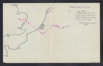
Outline map of England and north west Europe. Shows route to Homberg (near Duisburg) and return. Comments on anti-aircraft fire and being holed. Includes bomb load. Day operation.
Temporal Coverage
Type
Format
One map
Publisher
Rights
This content is available under a CC BY-NC 4.0 International license (Creative Commons Attribution-NonCommercial 4.0). It has been published ‘as is’ and may contain inaccuracies or culturally inappropriate references that do not necessarily reflect the official policy or position of the University of Lincoln or the International Bomber Command Centre. For more information, visit https://creativecommons.org/licenses/by-nc/4.0/ and https://ibccdigitalarchive.lincoln.ac.uk/omeka/legal.
Contributor
Identifier
CCuthillCR-180818-010001
Transcription
[map]
HOMBERG (DAY) 8 NOV 44
[symbol] [underlined] RONS WRITE UP. [/underlined]
HOMBERG AGAIN, FLAK still as accurate. We were holed in about a dozen places which pleased “[name indecipherable]” no end as it was his aircraft
(1x4000 – 6x1000 – 6x500)
(AMPG 1.00)
HOMBERG (DAY) 8 NOV 44
[symbol] [underlined] RONS WRITE UP. [/underlined]
HOMBERG AGAIN, FLAK still as accurate. We were holed in about a dozen places which pleased “[name indecipherable]” no end as it was his aircraft
(1x4000 – 6x1000 – 6x500)
(AMPG 1.00)
Collection
Citation
“Route map - Homberg,” IBCC Digital Archive, accessed July 26, 2024, https://ibccdigitalarchive.lincoln.ac.uk/omeka/collections/document/38401.
Item Relations
This item has no relations.

