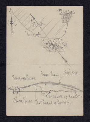
Map showing position of Tirpitz
Title
Map showing position of Tirpitz
Description
Top - sketch map of Tromsø Fjord with ship and bomb hits marked with x's and track line.
Bottom - annotated diagram sketch of upside down ship.
Bottom - annotated diagram sketch of upside down ship.
Temporal Coverage
Format
A page hand drawn map and diagram
Publisher
Rights
This content is available under a CC BY-NC 4.0 International license (Creative Commons Attribution-NonCommercial 4.0). It has been published ‘as is’ and may contain inaccuracies or culturally inappropriate references that do not necessarily reflect the official policy or position of the University of Lincoln or the International Bomber Command Centre. For more information, visit https://creativecommons.org/licenses/by-nc/4.0/ and https://ibccdigitalarchive.lincoln.ac.uk/omeka/legal.
Identifier
SGillK1438901v30054-0003
Collection
Citation
“Map showing position of Tirpitz,” IBCC Digital Archive, accessed July 27, 2024, https://ibccdigitalarchive.lincoln.ac.uk/omeka/collections/document/35717.
Item Relations
This item has no relations.

