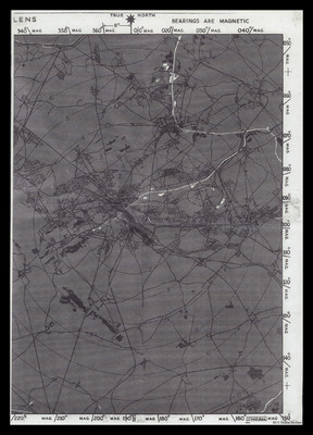
City of Lens Chart
Title
City of Lens Chart
Description
A chart used for bombing of the centre of Lens. Magnetic bearings are plotted on the outside and range circles from the centre are overprinted. It is centered on the marshalling yards. All the detail is grey or black but the canals, ponds and lakes are white.
Creator
Date
1944-03-17
Language
Format
One chart
Publisher
Rights
This content is available under a CC BY-NC 4.0 International license (Creative Commons Attribution-NonCommercial 4.0). It has been published ‘as is’ and may contain inaccuracies or culturally inappropriate references that do not necessarily reflect the official policy or position of the University of Lincoln or the International Bomber Command Centre. For more information, visit https://creativecommons.org/licenses/by-nc/4.0/ and https://ibccdigitalarchive.lincoln.ac.uk/omeka/legal.
Identifier
CSayFD-170912-02
Collection
Citation
Great Britain. Royal Air Force, “City of Lens Chart,” IBCC Digital Archive, accessed July 27, 2024, https://ibccdigitalarchive.lincoln.ac.uk/omeka/collections/document/20434.
Item Relations
This item has no relations.

