Browse Items (44 total)
- Tags: bombing of the Creil/St Leu d’Esserent V-1 storage areas (4/5 July 1944)
Last of the Tail Gun Charlies - Ronald Carter's Biography
At the age of 17, Ronald volunteered to join the Royal Air Force in November 1942. After basic training, Ronald was selected for gunnery and wireless operator training, becoming…
Tags: 44 Squadron; air gunner; aircrew; anti-aircraft fire; bale out; bombing; Bombing of Mailly-le-Camp (3/4 May 1944); bombing of Nuremberg (30 / 31 March 1944); bombing of the Creil/St Leu d’Esserent V-1 storage areas (4/5 July 1944); bombing of Toulouse (5/6 April 1944); Caterpillar Club; crewing up; mine laying; Normandy campaign (6 June – 21 August 1944); prisoner of war; RAF Dunholme Lodge; RAF Ringway; RAF Waddington; Stalag 3A; Stalag Luft 7; tactical support for Normandy troops; the long march; training; wireless operator / air gunner
Harold Wilson's flying log book
Tags: 14 OTU; 1654 HCU; 1660 HCU; 9 Squadron; 97 Squadron; Advanced Flying Unit; aircrew; Anson; Blenheim; bomb aimer; bombing of Luftwaffe night-fighter airfields (15 August 1944); bombing of the Creil/St Leu d’Esserent V-1 storage areas (4/5 July 1944); bombing of the Normandy coastal batteries (5/6 June 1944); C-47; Cook’s tour; Distinguished Service Medal; Halifax; Halifax Mk 2; Heavy Conversion Unit; Initial Training Wing; Lancaster; Lancaster Mk 1; Lancaster Mk 3; memorial; Normandy campaign (6 June – 21 August 1944); Operational Training Unit; Oxford; Pathfinders; RAF Bardney; RAF Bourn; RAF Coningsby; RAF Cottesmore; RAF Jurby; RAF Manby; RAF Market Harborough; RAF Middleton St George; RAF North Luffenham; RAF Oakington; RAF Saltby; RAF Scampton; RAF Swinderby; RAF Warboys; RAF Wigsley; training; Wellington
A short history of 640 Squadron
There is also a…
Tags: 4 Group; 617 Squadron; 640 Squadron; 9 Squadron; air gunner; aircrew; bomb aimer; bombing of Cologne (30/31 May 1942); bombing of the Creil/St Leu d’Esserent V-1 storage areas (4/5 July 1944); bouncing bomb; debriefing; Eder Möhne and Sorpe operation (16–17 May 1943); entertainment; final resting place; flight engineer; Gibson, Guy Penrose (1918-1944); ground crew; ground personnel; Halifax; Halifax Mk 3; love and romance; memorial; navigator; Normandy campaign (6 June – 21 August 1944); nose art; operations room; pilot; RAF Leconfield; RAF Lissett; superstition; tactical support for Normandy troops; Tirpitz; wireless operator
Raymond Harris's Pilot's log book
Tags: 1661 HCU; 17 OTU; 50 Squadron; 9 Squadron; Advanced Flying Unit; aircrew; Anson; bombing of Helgoland (18 April 1945); bombing of Luftwaffe night-fighter airfields (15 August 1944); bombing of the Creil/St Leu d’Esserent V-1 storage areas (4/5 July 1944); bombing of the Normandy coastal batteries (5/6 June 1944); Bombing of Trossy St Maximin (3 August 1944); Cook’s tour; Flying Training School; Fw 190; Harvard; Heavy Conversion Unit; Lancaster; Lancaster Finishing School; Normandy campaign (6 June – 21 August 1944); Operational Training Unit; Oxford; pilot; RAF Ansty; RAF Bardney; RAF South Cerney; RAF Sturgate; RAF Syerston; RAF Turweston; RAF Winthorpe; RCAF Bowden; Stearman; Stirling; tactical support for Normandy troops; Tallboy; Tiger Moth; Tirpitz; training; Wellington
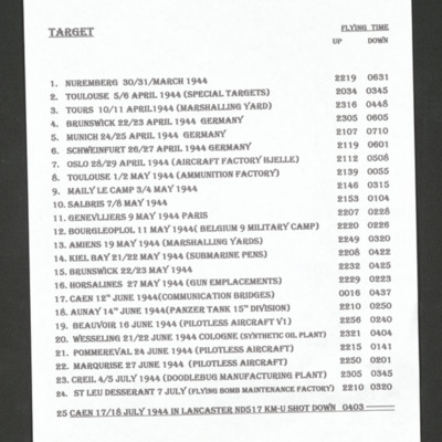
Ron Carter's List of Operations
Tags: 44 Squadron; Bombing of Mailly-le-Camp (3/4 May 1944); bombing of Nuremberg (30 / 31 March 1944); bombing of the Creil/St Leu d’Esserent V-1 storage areas (4/5 July 1944); bombing of Toulouse (5/6 April 1944); Lancaster; Normandy campaign (6 June – 21 August 1944); shot down; tactical support for Normandy troops; V-1; V-weapon
Ron Carter's flying log book
Tags: 44 Squadron; air gunner; aircrew; bale out; bombing; Bombing of Mailly-le-Camp (3/4 May 1944); bombing of the Creil/St Leu d’Esserent V-1 storage areas (4/5 July 1944); bombing of the Pas de Calais V-1 sites (24/25 June 1944); Lancaster; mine laying; Normandy campaign (6 June – 21 August 1944); prisoner of war; RAF Dunholme Lodge; shot down; tactical support for Normandy troops
Frank Howkins’ navigator’s, air bomber’s and air gunner’s flying log book
Tags: 1654 HCU; 27 OTU; 467 Squadron; 617 Squadron; Advanced Flying Unit; Air Gunnery School; aircrew; Anson; bombing of the Creil/St Leu d’Esserent V-1 storage areas (4/5 July 1944); bombing of the Juvisy, Noisy-le-Sec and Le Bourget railways (18/19 April 1944); bombing of the Normandy coastal batteries (5/6 June 1944); Dominie; Halifax; Heavy Conversion Unit; Lancaster; Lancaster Finishing School; Mosquito; Normandy campaign (6 June – 21 August 1944); Operation Catechism (12 November 1944); Operational Training Unit; Proctor; RAF Castle Bromwich; RAF Halfpenny Green; RAF Lichfield; RAF Syerston; RAF Waddington; RAF Wigsley; RAF Woodhall Spa; RAF Yatesbury; Tallboy; Tirpitz; training; Wellington; wireless operator
William James Herbert’s flying log book for navigator’s, air bomber’s and air gunner’s
Tags: 1654 HCU; 50 Squadron; aircrew; bombing; bombing of the Creil/St Leu d’Esserent V-1 storage areas (4/5 July 1944); bombing of the Pas de Calais V-1 sites (24/25 June 1944); Bombing of Trossy St Maximin (3 August 1944); Cook’s tour; flight engineer; Heavy Conversion Unit; Lancaster; Lancaster Finishing School; Normandy campaign (6 June – 21 August 1944); RAF Skellingthorpe; RAF Swinderby; RAF Syerston; RAF Wigsley; Stirling; tactical support for Normandy troops; training
Chris Scrimshaw's RAF navigator’s, air bombers and air gunner’s flying log book
Tags: 18 OTU; 61 Squadron; air gunner; Air Gunnery School; aircrew; Anson; bombing; Bombing of Mailly-le-Camp (3/4 May 1944); bombing of the Creil/St Leu d’Esserent V-1 storage areas (4/5 July 1944); bombing of the Juvisy, Noisy-le-Sec and Le Bourget railways (18/19 April 1944); bombing of the Normandy coastal batteries (5/6 June 1944); bombing of the Pas de Calais V-1 sites (24/25 June 1944); Bombing of Trossy St Maximin (3 August 1944); Lancaster; missing in action; Normandy campaign (6 June – 21 August 1944); Operational Training Unit; RAF Bishops Court; RAF Finningley; RAF Skellingthorpe; RAF Worksop; tactical support for Normandy troops; training; Wellington
Arthur Tindall's service and operations
Tags: 44 Squadron; 635 Squadron; 83 Squadron; 97 Squadron; aircrew; anti-aircraft fire; bombing; bombing of Kassel (22/23 October 1943); bombing of the Creil/St Leu d’Esserent V-1 storage areas (4/5 July 1944); bombing of the Normandy coastal batteries (5/6 June 1944); bombing of the Pas de Calais V-1 sites (24/25 June 1944); Distinguished Flying Cross; flight engineer; Gee; H2S; Lancaster; Mosquito; Normandy campaign (6 June – 21 August 1944); Oboe; Pathfinders; RAF Coningsby; RAF Swinderby; RAF Witchford; target indicator; V-weapon; wireless operator
Rear view - Ralph Briars memoir
Tags: 1661 HCU; 49 Squadron; 617 Squadron; air gunner; Air Gunnery School; aircrew; Anson; anti-aircraft fire; bombing; bombing of Nuremberg (30 / 31 March 1944); bombing of the Boulogne E-boats (15/16 June 1944); bombing of the Creil/St Leu d’Esserent V-1 storage areas (4/5 July 1944); bombing of the Juvisy, Noisy-le-Sec and Le Bourget railways (18/19 April 1944); bombing of the Le Havre E-boat pens (14/15 June 1944); Bombing of the Saumur tunnel (8/9 June 1944); bombing of the Watten V-2 site (19 June 1944); control caravan; control tower; Cook’s tour; crewing up; Distinguished Flying Cross; Distinguished Flying Medal; Halifax; Heavy Conversion Unit; Lancaster; Lancaster Mk 2; Me 109; mid-air collision; Mosquito; Normandy campaign (6 June – 21 August 1944); Normandy deception operations (5/6 June 1944); Operational Training Unit; RAF Cottesmore; RAF Dalcross; RAF Fiskerton; RAF Husbands Bosworth; RAF Linton on Ouse; RAF Market Harborough; RAF Winthorpe; RAF Woodhall Spa; Scarecrow; searchlight; service vehicle; Tallboy; Tirpitz; training; V-weapon; Wellington; Window
George Alexander Mackie’s pilots flying log book. Two
Tags: 11 OTU; 1651 HCU; 214 Squadron; aircrew; animal; arts and crafts; B-17; B-24; bombing; bombing of the Creil/St Leu d’Esserent V-1 storage areas (4/5 July 1944); C-47; Flying Training School; Heavy Conversion Unit; Initial Training Wing; military living conditions; mine laying; Normandy campaign (6 June – 21 August 1944); Operational Training Unit; Oxford; pilot; RAF Chedburgh; RAF Downham Market; RAF Nutts Corner; RAF Oulton; RAF Prestwick; RAF Sculthorpe; RAF Stoney Cross; RAF Tempsford; RAF Waterbeach; Stirling; training
Arthur Woolf’s flying log book for navigator’s, air bomber’s and air gunner’s
Tags: 16 OTU; 1654 HCU; 630 Squadron; Advanced Flying Unit; aircrew; Anson; bombing; bombing of the Creil/St Leu d’Esserent V-1 storage areas (4/5 July 1944); bombing of the Normandy coastal batteries (5/6 June 1944); Dominie; Heavy Conversion Unit; Lancaster; Lancaster Finishing School; missing in action; Normandy campaign (6 June – 21 August 1944); Operational Training Unit; prisoner of war; Proctor; RAF Barford St John; RAF Dumfries; RAF East Kirkby; RAF Syerston; RAF Upper Heyford; RAF Wigsley; RAF Yatesbury; shot down; Stirling; tactical support for Normandy troops; training; Wellington; wireless operator
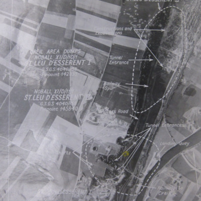
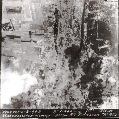
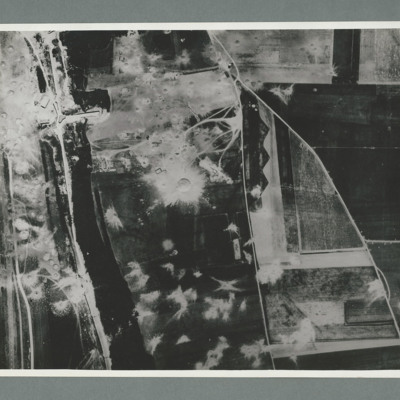
St Leu d'Esserent
Photo 1 is a vertical target photograph with tunnels, railway and landing quay marked.
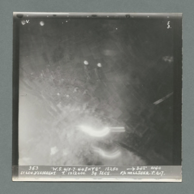
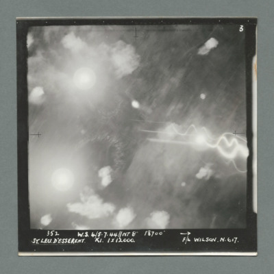
Photo 2 is a vertical aerial photograph taken during the operation. It is captioned '1962 TLP 5-8-44//8" 15000…
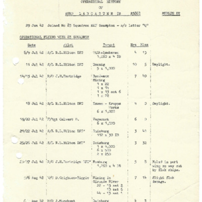
Operational history of Lancaster 1B R5868
Tags: 467 Squadron; 83 Squadron; bombing of Hamburg (24-31 July 1943); Bombing of Mailly-le-Camp (3/4 May 1944); bombing of the Creil/St Leu d’Esserent V-1 storage areas (4/5 July 1944); bombing of the Juvisy, Noisy-le-Sec and Le Bourget railways (18/19 April 1944); bombing of the Normandy coastal batteries (5/6 June 1944); bombing of the Pas de Calais V-1 sites (24/25 June 1944); Lancaster; mine laying; Normandy campaign (6 June – 21 August 1944); Pathfinders; RAF Bottesford; RAF Scampton; RAF Waddington; RAF Wyton; tactical support for Normandy troops; target indicator; V-1; V-weapon
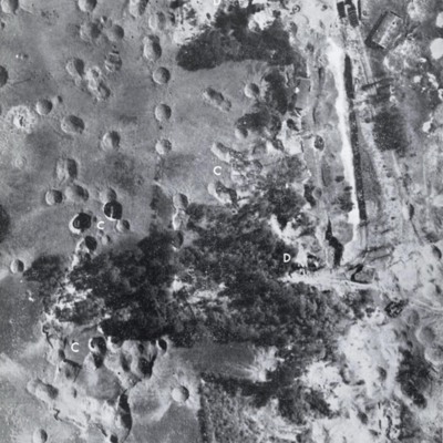
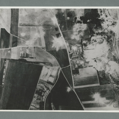
St Leu d'Esserent
Photo 1 is a vertical image showing bomb craters. It is annotated with 'C' and 'D's.
Photo 2 shows an entrance to an underground store.
Photo 3 show an entrance to an underground store. It…
St Leu d'Esserent
The caption reads '1962 TLP 5-8-44 // 8" 15000 --> 117° 1315:30 St Leu d'Esserent A(9x1000)(4x500)f30sec P/O Johnston "A" 420'
The second image is identical.
A bomber pilot’s journey through WWII
Tags: 11 OTU; 1660 HCU; 1668 HCU; 196 Squadron; 214 Squadron; 5 Group; 617 Squadron; 8 Group; aircrew; Bennett, Donald Clifford Tyndall (1910-1986); bombing; bombing of the Boulogne E-boats (15/16 June 1944); bombing of the Creil/St Leu d’Esserent V-1 storage areas (4/5 July 1944); bombing of the Juvisy, Noisy-le-Sec and Le Bourget railways (18/19 April 1944); bombing of the Le Havre E-boat pens (14/15 June 1944); bombing of the Mimoyecques V-3 site (6 July 1944); Bombing of the Saumur tunnel (8/9 June 1944); bombing of the Siracourt V-weapon site (25 June 1944); bombing of the Watten V-2 site (19 June 1944); bombing of the Wizernes V-2 site (20, 22, 24 June 1944); bombing of Toulouse (5/6 April 1944); Boston; C-47; Chadwick, Roy (1893-1947); Cheshire, Geoffrey Leonard (1917-1992); crash; Distinguished Flying Cross; Distinguished Service Order; final resting place; Flying Training School; Gibson, Guy Penrose (1918-1944); Grand Slam; grief; H2S; Halifax; Halifax Mk 3; Harvard; Heavy Conversion Unit; incendiary device; Lancaster; Lancaster Finishing School; Lincoln; Meteor; Mosquito; Normandy campaign (6 June – 21 August 1944); Normandy deception operations (5/6 June 1944); Oboe; Operational Training Unit; Oxford; P-51; Pathfinders; pilot; promotion; RAF Bassingbourn; RAF Boscombe Down; RAF Church Lawford; RAF Coningsby; RAF Cranage; RAF Cranwell; RAF Driffield; RAF Leconfield; RAF Stradishall; RAF Swinderby; RAF Syerston; RAF Upavon; RAF Wainfleet; RAF Woodhall Spa; Spitfire; Stirling; Tallboy; Tiger Moth; training; V-1; V-2; V-3; V-weapon; Wallis, Barnes Neville (1887-1979); Wellington
Arthur Atkinson’s observers and air gunners flying log book
Tags: 14 OTU; 1661 HCU; 17 OTU; 61 Squadron; Advanced Flying Unit; Air Gunnery School; aircrew; Anson; bombing; bombing of the Creil/St Leu d’Esserent V-1 storage areas (4/5 July 1944); bombing of the Juvisy, Noisy-le-Sec and Le Bourget railways (18/19 April 1944); bombing of the Normandy coastal batteries (5/6 June 1944); bombing of the Pas de Calais V-1 sites (24/25 June 1944); bombing of Toulouse (5/6 April 1944); Dominie; Heavy Conversion Unit; Lancaster; Lancaster Finishing School; Normandy campaign (6 June – 21 August 1944); Operational Training Unit; Oxford; Proctor; RAF Coningsby; RAF Halfpenny Green; RAF Husbands Bosworth; RAF Silverstone; RAF Skellingthorpe; RAF St Athan; RAF Stormy Down; RAF Syerston; RAF Winthorpe; RAF Yatesbury; Stirling; tactical support for Normandy troops; training; Wellington; wireless operator
V Group News, November 1944
Tags: 5 Group; 617 Squadron; 9 Squadron; air gunner; aircrew; bomb aimer; bombing; bombing of the Boulogne E-boats (15/16 June 1944); bombing of the Creil/St Leu d’Esserent V-1 storage areas (4/5 July 1944); bombing of the Mimoyecques V-3 site (6 July 1944); bombing of the Watten V-2 site (19 June 1944); bombing of the Wizernes V-2 site (20, 22, 24 June 1944); Distinguished Flying Cross; Distinguished Flying Medal; flight engineer; Gee; gremlin; H2S; Lancaster; Lancaster Finishing School; mine laying; navigator; Normandy campaign (6 June – 21 August 1944); Oboe; Operation Catechism (12 November 1944); pilot; radar; rivalry; Tallboy; Tirpitz; training; wireless operator
V Group News, July 1944
Tags: 5 Group; air gunner; air sea rescue; aircrew; bomb aimer; bombing; bombing of the Creil/St Leu d’Esserent V-1 storage areas (4/5 July 1944); bombing of the Mimoyecques V-3 site (6 July 1944); Cheshire, Geoffrey Leonard (1917-1992); Distinguished Flying Cross; Distinguished Flying Medal; Distinguished Service Order; ditching; flight engineer; Gee; H2S; Lancaster; mine laying; navigator; Normandy campaign (6 June – 21 August 1944); Oboe; pilot; radar; rivalry; searchlight; sport; tactical support for Normandy troops; training; V-2; V-3; V-weapon; wireless operator

![LHarrisRJ[Ser#-DoB]v1.pdf LHarrisRJ[Ser#-DoB]v1.pdf](https://ibccdigitalarchive.lincoln.ac.uk/omeka/files/square_thumbnails/1468/43464/LHarrisRJ[Ser -DoB]v1.jpg)
